Question bank

Chapter-1   Representation of Geographical Features
Q-1 Give four-figure grid references of the following:
(i) Trevor Tai _______________
(ii) Nakhi Talao _______________
(iii) Raj Bhawan _________________
(iv) DB (PWD) (North-west corner) ________________
Q-2 Give six-figure grid references of the following:
(i) Hanumanji Ka Mandir ________________
(ii) Gautam Maharishi Mandir _____________
(iii) Kodra reservoir __________________
(iv) Anodra Point ______________
Q-3 Give the meaning of the following:
(i) 1352 in grid square 6918 ___________________________________
(ii) House in grid square 6424 _________________________________
Q-4 Answer the following questions.
(1) Measure the direct distance in km from Kacholi Dungar (6316) to Ramkund ka Pahar (6621 ).
(2) What is the general slope of the land? Give reason for your answer.
(3) Explain the relief of the area.
(4) Name four man-made features in grid square 6923. Give their symbols.
(5) Name two natural features in grid square 6817.
(6) What does this symbol """"'" with 6r beside it in grid 6514 mean? What is the use of this feature?
Q-5 Give the settlement patterns of the following:
(i) Town Abu _____________________
(ii) In grid square 6424 _____________________
Q-6 Name the natural features in the following grids:
(i) 6818 _______________________________________________
(ii) 6918 ____________________________________________________
(iii) 7120 _____________________________________________________
Chapter-2   Population Dynamics
Q-1 Define the following terms and answer the associated questions:
(i) Birth rate : Is it true that a high birth rate is a characteristic of developing countries?
(ii) Overpopulation : Explain why is India is overpopulated.
(iii) Underpopulation : List three advantages of underpopulation.
(iv) Population density : Give three examples of regions which are sparsely populated.
(v) Sex Ratio : What is India's sex ratio?
Q-2 Give a suitable term for the following:
(i) A person who leaves his country and goes to reside in another country.
(ii) The type of population indicated by a concave sided triangular pyramid.
(iii) A diagram that shows the age-sex composition of a population.
(iv) The average number of years a person is expected to live.
(v) The average number of children a woman would bear during her reproductive years.
Q-3 Name:
(i) The country with the highest population.
(ii) The continent with the highest population.
(iii) Three countries whose pyramid depicts declining population.
(iv) Three countries whose pyramid depicts expanding population.
(v) Three factors that may bring about changes in the population structure of a country.
Q-4 State whether the following statements are true or false:
(i) Death Rate is the number of deaths per year.
(ii) Natural Growth Rate is the difference between the birth rate and the death rate and is expressed as percentage.
(iii) If the birth rate is greater than the death rate, then the growth rate is said to be negative and there is a decrease in the population.
(iv) In general, developing and underdeveloped countries have a high growth rate of population.
(v) In general, developed countries have a low growth rate of population.
(vi) Emigration is the movement of people into a country or territory.
(vii) Immigration is the movement of people out of a country or territory.
(viii) Relief of a country is a part of the demographic structure of a population.
(ix) In a population pyramid, the oldest age group is shown at the bottom.
(x) Demography is the statistical study of all aspects of population.
Chapter-3   Migration
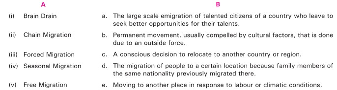
Q-1 Match the items in column A with the appropriate description in column B.
Q-2 People move from one place to another due to factors which can be classified as 'push factors' and 'pull factors'. Identify the factors given below as push or pull factor.
( i) Unemployment ________________________
(ii) Political security _____________________
(iii) Poverty _____________________
(iv) Safe atmosphere __________________
(v) Fertile land ______________________
(vi) Attractive climate __________________
(vii) Less risk of natural hazards _____________________
(viii) High crime rate ___________________
(ix) Religious intolerance ________________
{x) Better education ___________________
Q-3 Rural-urban migration has certain shortcomings. Mention any three drawbacks.
Q-4 State whether the following statements are true or false:
(i) Emigration reduces the burden on resources of the rural and overpopulated countries.
(ii) Brain drain creates a social and economic disparity in the native country.
(iii) Human capital flight is another term for brain drain.
(iv) Non Resident Indians are people who are not Indian citizens but have Indian ancestry.
(v) The migrant population is usually a minority in the host country.
Multiple Choice Questions
Q-1 Which of the following is not a satellite city?

(i)

Gurugram

(ii)

Yelahanka

(iii)

Pune

(iv)

Thane
Q-2 Which of the following is not a smart city?

(i)

Seoul

(ii)

Indore

(iii)

Patna

(iv)

Amsterdam
Chapter-4   Urbanisation
Q-1 Urbanisation is the term used to describe mass movement from rural areas to urban areas.
(a) Which of the following is a push factor in urbanisation? (i) Better service provision (ii) Greater wealth (iii) Unemployment (iv) Improved health care

(b) Urbanisation can cause a number of problems. Which of the following is not an issue in more economically advanced nations? (i) Transport congestion (ii) Open sewers leading to disease (iii) Housing pressures (iv) Pollution

Q-2 Answer the following questions.
(a) List three ways urbanisation affects the environment.
(b) How are jobs affected by urbanisation?
(c) List three factors that have led to urbanisation in India
(d) List three positive effects of urbanisation.
(e) List three negative effects of urbanisation. State how the adverse effect of urbanisation can be minimised.
(f) What is a satellite city? In what way does it differ from a suburb?
(g) What is a smart city?
Q-3 Fill in the blanks:
(i) A ___________ city has its own Municipal Corporation.
(ii) _____________ ___________ is a human settlement with high population density and infrastructure of built environment.
(iii) ___________ is the only Indian city to rank among the top 20 global smart cities.
(iv) ___________ is a satellite city of Hyderabad.
(v) Rural areas act as the _________ factor while urban areas are the _____________ factor for urbanisation.
Chapter-5   Natural and Man-made Disasters
Q-1 Give three examples of each:
(i) Natural disasters caused by geological factors.
(ii) Natural disasters caused by climatic factors.
(iii) Man-made disasters.
Q-2 What is a hybrid disaster? Give any one example.
Q-3 Answer the following questions.
(1) What is a flood? List three factors that cause floods.
(2) What is a drought? List three effects of droughts.
(3) What are the common objectives during any disaster?
Q-4 Name a region in India that is prone to:
(i) Earthquakes
(ii) Floods
(iii) Drought
(iv) Cyclones
Q-5 State whether the following statements are true or false:
(i) Developing and practicing an emergency plan occurs during the response phase of disaster management.
(ii) During the mitigation phase of disaster management, the situation is stabilised and the immediate danger is assessed.
(iii) The name of cyclones in Australia is typhoon.
(iv) The length of Indian coast line is approximately 7,500 km.
(v) During an earthquake, it is advisable to stay away from heavy objects and other such items that may fall and cause harm.
Q-6 Write a brief note on each of the following
(i) Floods in Assam
(ii) Earthquake in Nepal
(iii) Oil spills in coastal USA
Multiple Choice Questions
Q-1 From where are earthquake waves generated?

(i)

Focus

(ii)

Epicentre

(iii)

Solid inner Core

(iv)

None of these
Q-2 Tsunami is:

(i)

Earthquake on land mass

(ii)

Volcanic eruption

(iii)

Earthquake in ocean crust

(iv)

None of these
Q-3 When did Tsunami strike the east coast of India in recent times?

(i)

December 26, 2004

(ii)

December 26, 2014

(iii)

December 24, 2004

(iv)

January 26, 1997
Q-4 The point in the earth from which seismic waves spread out in all direction is

(i)

Earthquake focus

(ii)

Seismic Center

(iii)

Epicentre

(iv)

None of these
Q-5 Which part of disaster management involves predicting a possible crisis before it occurs?

(i)

Mitigation

(ii)

Preparedness

(iii)

Response

(iv)

Recovery
Chapter-6   Asia
Q-1 Name or state:
(i) The latitudes and longitudes within which Asia lies.
(ii) The sea through which the International Date Line passes.
(iii) An island of Indonesia which is divided by the Equator.
(iv) The mountains that separate Asia from Europe.
(v) The peninsula that connects Asia with Africa.
(vi) The strait that separates Asia from North America.
(vii) Three seas along the east coast of Asia.
(viii) The oceans that surround Asia on the: a. East b. North c. South
(ix) The two big bays to the south of Asia.
(x) Two large islands of Indonesia.
Q-2 Answer the following questions.
(i) Name the five physical divisions of Asia.
(ii) In which physical division of Asia are the following rivers, mountains and lakes/seas found? a. River Yablonoi b. Altyn Mountains C. River Godavari d. Aral Sea e. Pontic mountains f. Karakoram Range g. River Tigris h. Altai Mountains i. Amu Darya j. Plateau of Shan
Q-3 Answer the following questions.
(i) What is an intermontane plateau?
(ii) Name two intermontane plateaus found to the: a. Southwest of the Pamirs b. East of the Pamirs
(iii) Name the mountains that enclose each of the plateaus named in 3(ii)
Q-4 Explain the following terms:
(i) Dissected plateau
(ii) Peninsula
(iii) Archipelago
Q-5 Fill in the blanks:
(i) The __________ mountains separate Asia from Europe.
(ii) Lake __________ is the world's deepest fresh water lake.

(iii) Bahrain is an island in the __________Gulf.

(iv) Yaks are found in the __________ Plateau.
(v) The Huang He and ____________________ are two important rivers of China.
(iii) Bahrain is an island in the --------- Gulf.
Q-6 State whether the following statements are true or false:
(i) Middle East is a loosely defined region which includes South Asia and Southeast Asia.
(ii) The Siberian river plains are unsuitable for cultivation.
(iii) The Aral Sea is a salt water lake.
(iv) The Pamir Knot is located in Asia Minor.
(v) The Arabian Sea extends into Asia as the Red Sea.
Q-7 Mention the effect of the:
(i) Himalayas on the climate of the Indian sub-continent.
(ii) Oyashio current on the climate of Japan.
(iii) Kuroshio current on the climate of Japan.
(iv) The Monsoon Winds on the climate of the Indian sub-continent.
Q-8 Answer the following
(i) State the main characteristics of the Equatorial type of climate.
(ii) Name two Asian countries that experience the Equatorial type of climate.
Q-9 Identify the climatic region from the clues and characteristics mentioned below:
(i) Teak is the most important tree of this type of forest.
(ii) The daily range of temperature is greater than the annual range of temperature.
(iii) It receives rain only in winter.
(iv) It lies between the latitudes 55°N and 70°N.
(v) Northeast China experiences this type of climate.
(vi) Summers are short and warm, while winters are long and severe.
(vii) Summers are short and cool, while winters are long and severe.
(viii) It experiences hot summers, cold winters and scanty rainfall.
(ix) The daily range of temperature is very small.
(x) The plateau of Mongolia lies in this region.
Q-10 Distinguish between the tropical deserts and temperate deserts on the basis of
(i) Location
(ii) Climate
(iii) Vegetation
Q-11 Mention the economic importance of the following animals:
(i) Reindeer
(ii) Camel
(iii) Mink and Sable
(iv) Elephants
Q-12 Explain why:
(i) The Sea of Japan is one of the best fishing grounds of the world.
(ii) Asia experiences tropical, temperate and extremely cold climates.
(iii) Explain why the ancient civilisations developed in the river valleys.
(iv) Northern Asia has scanty population.
(v) Southeast Asia has heavy population.
Q-13 Answer the following questions.
(i) Who are nomads? List the characteristics of nomadic herding.
(ii) What are the nomads of the following regions called? a. Saudi Arabia b. Central Asia
Q-14 Answer the following questions.
(i) Name the type of forests that yield hard wood trees.
(ii) Give three examples of each. a. Hard wood trees b. Soft wood trees.
Q-15 Answer the following questions.
(1) What is aquaculture?
(2) Name the four areas of heavy industrialisation in Asia and mention one country from each region.
Q-16 Fill in the blanks
(i) The greatest natural wealth of Asia is _______________
(ii) __________ is the largest producer of petroleum in Southeast Asia.
(iii) India's __________ Project is one of the largest multipurpose projects in Asia.
(iv) __________ is the most densely populated continent.
(v) __________ and are the largest producers of iron ore in Asia.
(vi) __________ is the most industrialised country in Asia.
(vii) __________ and __________ Asia have very scanty population due to severe climatic conditions.
(viii) Most of the people who live in __________ Asia are herders and great horseman.
(ix) v and __________ are among the least industrialsied countries of Asia.
(x) In China, farming is carried on in paddy fields.
Q-17 Answer the following questions.
(a) What is the basis for dividing the nations of the world into developing and developed nations
(b) List four differences between developing countries and developed countries.
(b)(ii) List four differences between developing countries and developed countries.
Q-18 Name the country in which are the following seaports located?
(i) Aden
(ii) Karachi
(iii) Yangon
(iv) Singapore
(v) Ho Chi Minh City
(vi) Manila
(vii) Hong Kong
(viii) Tokyo
(ix) Chennai
(x) Colombo
(xi) Kuala Lumpur
(xii) Shanghai
Q-19 Find out the name of the National airlines of the following countries:
(a) Israel
(b) Jordan
(c) United Arab Emirates
(d) Hong Kong (China)
(e) India
(f) Nepal
Q-20 State whether the following statements are true or false:
(a) Tamil is a Sanskritic language.
(b) Mandarin is a Chinese dialect.
(c) Pashto is the language of the Afghans.
(d) Sinhalese belongs to the Dravidian group of languages.
(e) Khmer is the language spoken in Cambodia.
Chapter-7   India
Q-1 Answer the following questions.
(a) What is a subcontinent? Name the countries that make up the subcontinent of Asia.
(b) State the latitudes and longitudes between which India lies.
Q-2 Answer the following questions.
(a) What is the basis for the political divisions of India?
(b) Into how many states is India divided?
Q-3 Answer the following questions.
(a) What is a Union Territory? How many Union Territories are there in India?
(b) Name the Union Territories of India.
Q-4 Name any two states that:
(a) Have a common border with Bangladesh.
(b) Form international borders with neighbouring countries.
(c) Form the coast of India.
(d) Are part of the Great Peninsular Plateau.
(e) Do not have an international border, or lie on the coast.
(f) Lie completely in the Himalayas.
(g) Are made up of hills in north-east India.
(h) Have a common border with Pakistan.
Q-5 Answer the following questions.
(a) Name the two main mountain ranges that constitute the Great Mountain Wall of the north.

(b) In which of the ranges named in (a) are the following located. a. K2 peak b. Himadri range c. Baltoro glacier d. Gangotri e. Shiwalik ranges f. Shimla

Q-6 Answer the following questions.
(a) Name the river that divides the Peninsular Plateau of India into two parts.
(b) Name the two parts of the Peninsular Plateau of India.

(c) Name the landforms that form the boundaries of each of the parts named in (b).

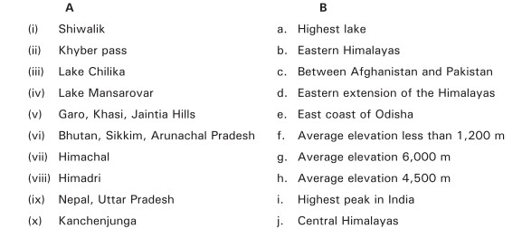
Q-7 Match the items in column A with the appropriate items in column B.
Q-8 Answer the following questions.
(a) Name the two river basins that make up the Northern Plains.
(b) State the location of the Great Indian Desert.
(c) Explain why this is an area of inland drainage.
Q-9 Pick out the odd member and give a reason for your selection.
(a) Chenab, Jhelum, Ravi, Beas, Yamuna.
(b) Tista, Ghaghara, Gandak, Kasi, Jamuna.
(c) Son, Chambal, Betwa, Yamuna, Damodar.

(d) Subansiri, BaraIi, Manas, Dihing.

(e) Hardwar, Kanpur, Delhi, Patna, Barauni.
Q-10 Name two rivers of the Peninsular Plateau that flow:
(i) Eastwards
(ii) Westwards
Q-11 Name:
(a) The highest peak of the Western Ghats.
(b) The longest river of the Deccan Plateau.
(c) The highest peak of the Eastern Ghats
(d) A river of the Peninsular Plateau that does not form a delta.
(e) A braided river.
(f) The longest river in India.
Q-12 Answer the following questions.
(a) "India is a land of sharp climatic contrasts". Give three examples to justify this statement.
(b) What is alpine vegetation?
Q-13 Answer the following questions.
(a) What is the basis for determining the seasons in India?
(b) Name the four seasons in India and mention the period (months) during which each prevails.
Q-14 Identify the season from the general characteristics provided.
(a) Hot and humid; heavy rains along the east coast of India
(b) Pleasant, clear skies and low humidity; rainless, except the east coast and north-west India.
(c) Hot and dry over most of India, occasional storms.
(d) Heavy rains throughout India, except Tamil Nadu.
Q-15 Give geographical reasons

(i) The Deccan Plateau is relatively warmer than the Northern Plain during winter.

(ii) The Deccan Plateau is relatively cooler than the Northern Plain in summer.

(iii) The Deccan Plateau receives less rainfall while the Ganga-Brahmaputra delta gets heavy rains during the Southwest Monsoon season.

(iv) Tamil Nadu does not get rain during the Southwest Monsoon season.

(v) Rajasthan does not get much rain during the Southwest Monsoon season.
Q-16 Name the types of forest based on:
(a) Variation of rainfall.
(b) Variation of relief
Q-17 Answer the following questions.

(a)  Mention three characteristics of the Tropical Evergeen forest.


(b) Differentiate between a Tropical Deciduous forest and a Temperate Deciduous forest.

Q-18 Answer the following questions.
(a) In which parts of India are the Thorn forests found?

(b) Mention two characteristics of the plants that grow in this region.

Q-19 Name two common plants of the following regions:
(a) Thorn forest
(b) Tropical Evergreen forest
(c) Tropical Deciduous forest
(d) Temperate Deciduous forest
Q-20 Answer the following questions.
(a) What are the tidal forests called in the Ganga-Brahmaputra delta?
(b) Name the most important tree of the Tidal forest
(c) State one characteristic of trees growing in the Tidal forest.
Q-21 Answer the following questions.
(a) Why are forests considered an important natural resource?
(b) Mention three minor forest products and give one use of each.
Q-22

Answer the following Questions. 

(a) What is the Western Coastal Plain known as in: i. Maharashtra ii. Karnataka iii. Kerala 

(b) State two characteristics of each of the following. i. Western Coastal Plain ii. Eastern Coastal Plain

(c) Where in India are the following animals found: i. Lion ii. Tiger iii. Rhinoceros

(d) Name any two of each of the following: i. Wildlife Sanctuaries in India ii. Bird Sanctuaries in India iii. National Parks in India

Q-23

State whether the following statements are true or false.

(a) Mizoram has the lowest population in India.

(b) Uttar Pradesh is the largest (in size) state of India.
(c) The longitude of 82 °30' Wis taken as the Standard Time Meridian of India.
(d) India has a fairly regular coastline.
(e) Indira point is the southern-most point of India.
(f) Lakshadweep is a group of islands in the Bay of Bengal.
(g) The Gulf of Khambhat separates India from Sri Lanka.
(h) Minicoy belongs to the Andaman and Nicobar group of islands.
(i) The Gulf of Kachchh is found along the coast of Gujarat.
(j) India has an area of 3.2 million sq. km
Chapter-8   India: Human Resources
Q-1 Fill in the blanks:
(a) The Indian population reached the billion mark in ________
(b) The average life expectancy of Indians is about ________
(c) The _________ region and the _________ states are sparsely populated.

(d) ____________, ____________ is the most populous state of India.

(e) It is expected that in 2020 the average age of an Indian will be _________ years.
Q-2 Give one term for the following:
(a) Cities with a population of more than a million people.
(b) The skilled and unskilled workers of a country and the knowledge and effort they bring to work.
(c) A useful or valuable possession of a country, orgnanisation or person.
(d) Number of persons per sq. km.
(e) The population that lives in villages.
Q-3 State whether the following statements are true or false:
(a) Health and education are the two vital factors for the economic progress of a country.
(b) Unskilled workers get low wages as compared with skilled workers.
(c) A dietician is an unskilled worker.
(d) In India, more women work in cities than in rural areas.
(e) India's population has been declining since 1981.
Q-4 Answer briefly:
(a) India needs to invest in skill development programs for its youth.
(b) A developing country like India would benefit by increasing its women workforce.
(c) Even a non-productive age group needs to be healthy.